CHASM OF THE VIRGEN or
 NEPTUNE CAVE
 COVE AGUILAR
MASSIF OF THE MUELA
CARTAGENA
MURCIA
SPAIN
Coordinates Entrance I shaft
X : 667.670
Y : 4.159.640
Z : 37 m.s.n.m.
Y : 4.159.640
Z : 37 m.s.n.m.
Coordinates Entrance II inmersed
X : 667.670
Y : 4.159.548
Z : -12 m.s.n.m.
Y : 4.159.548
Z : -12 m.s.n.m.
Development: 135 metres.
Uneveness: 32,50 metres deepness
Uneveness: 32,50 metres deepness
and-12 metres deepness at lake.
 Temperature : 16 ºC month of January and 25,4 ºC in the month of June. Humidity : 68 %.
 Temperature : 16 ºC month of January and 25,4 ºC in the month of June. Humidity : 68 %.
 PRESENTATION
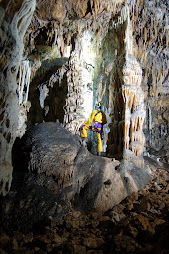
Located in the West of Cartagena in the Cove Aguilar in the Massif of the Muela, the Chasm of the Virgin is an underground system of tectonic origin and developed in limestones and dolomites tabled gray/bluish of Malm. The chasm of the Virgin is also known as the Neptune cave, due to have an underwater entrance.
The Chasm of the Virgin is one of the most important Mediterranean cavities that forms a complex biological system unique and singular, since it has developed in its interior a mass plant consists mainly of a Fig Tree (Ficus carica) and a Palm tree (Chamerops humilis), which is the biggest in Europe with more that 5 meters grown.
The Chasm of the Virgin is one of the most important Mediterranean cavities that forms a complex biological system unique and singular, since it has developed in its interior a mass plant consists mainly of a Fig Tree (Ficus carica)
 and a Palm tree (Chamerops humilis), which is the biggest in Europe with more that 5 meters grown.
 CHASM OF THE VIRGIN or NEPTUNE CAVE
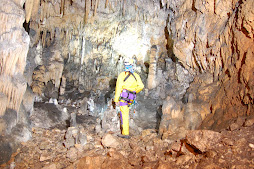
The Chasm of the Virgin consists in a single hall with development direction Northeast Southwest with an inclination of 34 ° and with a total length of 135 meters with two different entrances, the first caused by the collapse of the dome creating an entrance with 7 meters lenght and 16 meters wide, with an entrance shaft of 14 meters deep.
The main hall is filled by a large number of blocks from outside some of which are unstable and  others are fossilized by the calcium carbonate.
 others are fossilized by the calcium carbonate.
The forms of deposit of calcium carbonate are scarce in the cavity and some of the more developed are now submerged in the lake in the cavity. In the extreme east of the Chamber in the zone boundary between the land and water area there is an upwelling of water which gives the brackish waters of the lake.
The entrance to this cave is done by the pit 14 meters that promotes a vertical absolute 14 meters and is the direct entry to the great hall of the system. Traditionally entry was performed by the side of the pit down a wall leaning but with many small steps to reach a ledge that makes up a small room and from which descended into opposition by a crack until you reach a large rock from which it comes easily to the ground.
The entrance to this cave is done by the pit 14 meters that promotes a vertical absolute 14 meters and is the direct entry to the great hall of the system. Traditionally entry was performed by the side of the pit down a wall leaning but with many small steps to reach a ledge that makes up a small room and from which descended into opposition by a crack until you reach a large rock from which it comes easily to the ground.
To facilitate maneuvering down a marronner was placed in the widest part of the crack and at the  halfway descent of this stretch.
 halfway descent of this stretch.
This access allows a side entrance to the cave without too many complications, but not without risk and with only a scale of wood or with a rope or wrongly, according to some fishermen in the Azohia and Portús, could reach the floor and then the lake. On one side of the lake had installed a Virgin of which today is only the pedestal.
Because of its particular microclimate conditioned by the large entry to the single chamber system, some species from abroad have colonized these lands proliferating in a way protected and isolated elements aggressive foreign conferring a special development of these two species, Figus tree (Ficus carica) and Palm tree (Chamerops humilis) and a significant adaptation to the environment underground.
The external features of the  cave and vegetation prevailed in an atmosphere of closeness to the coast where there is a high concentration saline coupled with a high average temperature, conditioned by the erosion of the media, has created an environment with little postage tree where they have proliferated mainly Pine (Pinus halepensis) and Palm tree (Chamerops humilis).
 cave and vegetation prevailed in an atmosphere of closeness to the coast where there is a high concentration saline coupled with a high average temperature, conditioned by the erosion of the media, has created an environment with little postage tree where they have proliferated mainly Pine (Pinus halepensis) and Palm tree (Chamerops humilis).
GENESIS
In tectonic origin, the trough of the Virgin or cave Neptune is a cavity conditioned by a strong fracturing from North to South comprising Malm dolomites and limestones tabled bluish and gray.
In tectonic origin, the trough of the Virgin or cave Neptune is a cavity conditioned by a strong fracturing from North to South comprising Malm dolomites and limestones tabled bluish and gray.
PLANT OF THE ENVIRONMENT
The vegetation of the area is tied to a Mediterranean climate.
 Launaea arborescens
 Launaea arborescens
Lycium intricatum
Rhus oxyacantha
Zilla spinosa
Ziziphus lotus
Rhamnus lycioides
Chamerops humilis
Asparagus stipularis
Olea europea
Asparagus albus
Ceratonia siliqua
Periploca laevigata
 Arenaria montana
Pistacia lentiscus
Rosmarinus officinalis
Tymus glandulosus
Pinus halepensis

TOPOGRAPHY
The topografy of the cave has been entirely made with Suunto instruments and devices such as Suunto Tandem, Suunto X Lander and Suunto E203.
Mesuring of altitud have been made thanks to Suunto X Lander. Length measures have been made with laser.

View of the under water entrance of the Chasm of the Virgin called by this entrance the Neptune cave.
In the bottom of the entrance there is a stone Virgin.
The topographic works of the Chasm of the Virgen or Neptune cave have been made thanks to the precision of the Suunto Tandem, so as mesurings of the altitud have been made with the Suunto X Lander and Suunto E203. Divings have been trusted with the Suunto Mosquito. All  master pieces to enjoy the world.
 master pieces to enjoy the world.
 The Suunto ABC, Altimeter, Barometer and Compass has become a necessary tool for outdoor activities, providing a valuable information about climate, altitude and precision bearing to follow the correct course. If you get lost or misleaded due to a changing weather, you know you have a tool on which you can count on and be able to reach a fixed place or a sure shelter, that is just a way to replace luck. In the mountains and in caves the luck is only a point of view, what you really need is a master piece able to guide and on which you have the trust, that's a Suunto. This makes you feel free and in complete liberty. We are using the  Suunto compass for topography inside caves so as the clinometer to define corridors and halls inclinations, with very nice results and precisions, that gives us an outstanding information that provides the necessary data to be able to draw the map of the cave with accuracy, showing the corresponding morphology of the underground. That is a Suunto essential ability. The altimeter inside a cave provides us with a prompt and precise information that is very useful to calculate the depth of shafts in order to explore with security. We trust Suunto.

No comments:
Post a Comment